Goldfields Getaway
7 April, 2021
Inglewood, St Arnaud, Bealiba and Dunolly
Total travelling time is around three hours and distance around 160km from Inglewood to Dunolly. Start and finish where you like. In this tour we are looking at the area west of Inglewood. Inglewood has a number of collectable stores, some old...
Total travelling time is around three hours and distance around 160km from Inglewood to Dunolly. Start and finish where you like.
In this tour we are looking at the area west of Inglewood. Inglewood has a number of collectable stores, some old historic properties, a couple of pubs, a rustic furniture maker, a gold jewellery creator, artists, and an interesting car museum – phone Denis on 0407 453 646 to see when the museum is open.
On the north side is The Blue Eucy eucalyptus plant showing working demonstrations, you can stop for a cuppa at the café and purchase some great eucalyptus products. From here, head out west from the Royal Hotel past the Town Hall.
Next stop, Kingower, see the restored church, the school house and old hotel, and maybe visit the wineries (if they are open).
Another piece of history is the watering hole, or well, used by the coachmen to water their horses.
To find the watering hole go down the track leading to the entrance of Blanch Barkley Wines and keep going around another 300 meters and you will find the marked waterhole on your left.
The ruins of the old Unlea Reef Mine is opposite.
Just be careful as it looks more like an open cut piece of mining but holes were often covered up and the timbers will not be so stable these days.
Major Mitchell spent a lot of energy and time travelling throughout NSW and Victoria circa 1836.
He travelled through the Pyrenees district on at least two occasions and had a long stay for an unknown reason in the area adjacent to the Melville Caves.
This was unknown to this author until quite recently when a collection of rocks, similar to the rings of stone pattern found in the UK, was pointed out to me, by a local citizen of some repute, as the location of a fort used by Major Mitchell.
This is a site that is best visited by a four wheel drive, although a high clearance vehicle could negotiate the area in fine weather. Take the Back Road from the Melville camping area for a distance of 1.4 km. You are now in the suggested area of the fort and it is perhaps on your right.
The alternative is a walk down one to two kms from the upper camping area at Melville Caves taking the Southern Walking Circuit (this is over six kms in length so be careful in going too far in one effort as the rocks are not marked at all) and returning.
You can also walk down the eastern trail to Back Road and turn right down the road for around 500 metres and look into the rocks on the right.
Take a moment to imagine how the troops defended themselves, with wagon placements etc… It is advisable that you use the internet to gain maps and data before moving around the off bitumen trails and roads.
Another piece of folklore as to Melville’s exploits was the holdup routine. Apparently, they would watch out from the high granite rocks for the coaches approaching from the north, then jump down and carry out the holdup before hightailing it down through the rocks to their horses. The horses were “stabled” below the steep sloped area of many rocks. They would then ride away to the west or south.
Another piece of history is the Logan Pub. It has been a favoured place to visit for a very long time.
It is well worth a visit as you head across to St Arnaud. The road works have altered over the years so parking is limited in front now.
There is another monument to Major Mitchell just past Logan on the road to St Arnaud. It is on your left.
Here, in St Arnaud, there are a number of buildings of the past, take a stroll up and down the main street and try to work out what the buildings might have been in their heyday. I noted the old State Savings Bank is still showing its label despite being painted over.
For such a low population there is much evidence of grander days. A great park as well. The shopping strip is as large as any town 10 times the population with some beautiful stores and modern refurbished hotels.
Head south and look for the turn to Dunolly on the left (if you wish you may drive on to Avoca, etc, taking the turn to Dunolly and look for Murray Road on your right). The town and forest in this area is Carapooee, the name itself makes you ask “what the?”. To have a quick look, turn right down the Murray Road and what’s left is within two to three kms from the corner.
Return to the Dunolly road and head on to Emu.
Of note along here just over the Carapooee Creek on the left, is a beautiful stone church and on the right an equally beautiful stone homestead. Emu is very small but evidence of a busier time is still showing. The local primary school was built in 1803, so compare that with the oldest primary school in Maryborough at 404 Primary, built in 1808 – it has been around a long time!
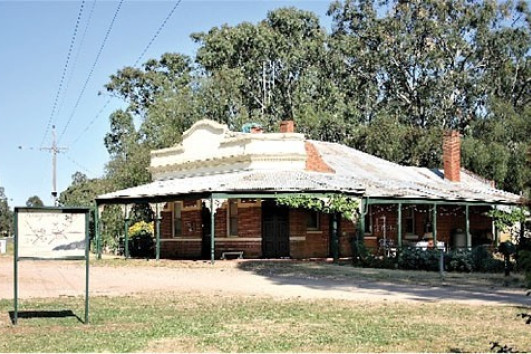
Drive on to Bealiba for a look at the beautiful old Bealiba Railway station and take a drive down the back streets to see a number of interesting historic buildings. Now drive on to Dunolly for a well-earned break.
I hope you enjoyed your enriching Victorian cultural driving tour, let me know your feedback 0439 029 989.