Goldfields Getaway
31 March, 2021
BURNT CREEK TOUR
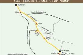
On this tour we are going to the location of Burnt Creek that became Bromley in 1864. Head south from Dunolly central towards Maryborough and at the motel turn left, go approximately 500m and turn right towards Betley. At the next “V”...

On this tour we are going to the location of Burnt Creek that became Bromley in 1864.
Head south from Dunolly central towards Maryborough and at the motel turn left, go approximately 500m and turn right towards Betley.
At the next “V” intersection turn off to the left and a few metres down this Middle Road you will see, on the right, the Bromley School. This is a stone building that was built by local efforts and opened in 1868.Vaughan was the successful headmaster of the time when the school had 120 pupils in attendance with a waiting list.
The shelter shed that appears on the west fence was built much later. Turn right at the school and turn left back onto the Betley Road and travel down to the bridge (about 1km). This is the new bridge built as Anderson Street was the main road out of Dunolly (Eddington Road was built later).
As you cross the bridge you are actually entering the original village of Burnt Creek (even though the area of Burnt Creek started back at the turn off Eddington Road).
Burnt Creek really started to be a serious mining area with a rush of 4000 in 1855. Now, as you cross the bridge, you have to imagine a bit here as to your left was a crushing plant and to your right on the flat ground was the original David Kirk Store, which had to be shifted from the original site that was impinging on the new road.
David had been one of the earliest businesses and had not only built the store but the original bridge.
If you turn immediately right and go up the track you will get to the original Burnt Creek Cemetery. Details of the people involved are on the notice boards.
If you want to investigate further in this area, look beyond the cemetery and you will see the original dam wall. This dam was constructed to gather water via a channel from Bet Bet Creek, which was then used by the dredges.
Return to the Betley Road and turn right and park. You need to walk over the flat area to your right and toward the tailings (dirt and rock from mining), aiming for the left hand corner, and then climb up to your left.
At the top you will see a sudden drop into the pit left by the dredge. This proved to be the end of dredging on this run due to hitting a quartz reef (the reef is at the far end). Note on the left hand side, the entrance of the water channel.
Return to your car and further along just to your left is the second effort with the dredge. It was dismantled and shifted to just in from the bridge on the left side of the road. It continued to the large hole still there when it ended in an old creek bed.
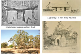
Now back to the right hand side of the road to the location of the largest Joss House in the district, a store (varied over time), a hotel and possibly another business on the other side of a lane.
The space between the new entrance road to a new house and the old lane was most likely where the stables and parking area for the hotel was located (this area has an oak tree and a large Mulberry tree).
I am having trouble finding definitive data as to where the up-to-3000 Chinese people lived. I believe some lived in the area behind the houses and businesses on the main street but near to the Joss House.
It is known there was a China town on the north side of the creek and near their Hong Kong Mine that was north of the church.
Next on the right are two houses, one being one of the oldest houses still standing (it most likely was a business at one time and also note the stone work). Continue on and pass Melton’s Lane to the left but then there is a turn to the right to Timor.
The area between that road and the angular road (Treble Lane) corner on your far right was/is the Burnt Creek Common.
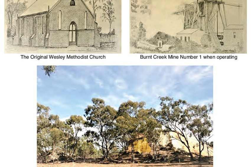
Next is the space on the corner (sharp corner) – it is the location of the Treble Store – the last store to operate in the area. Now some imagination is needed because the Methodist Church and police precinct were behind the current house in the middle of the paddock.
There were possibly up to four main rushes here over the years and the population varied from 2000 to 900 to 60,000 if you believe what is written.
I suspect the latter number had the Dunolly numbers included as the whole area was a mass of miners. In the big rush there were mines over a mile to the north of the railway line on Broadway, right out to Betley and Bet Bet with other pockets as well.

